What Is a Phase 1 Habitat Survey and When Do You Need One?
Most planning applications for development in England now come with an ecological survey requirement attached. For a lot of applicants – particularly those coming to development from a property or commercial background rather than a planning one – the first time they encounter the words “Phase 1 habitat survey” is when a planning officer or pre-application consultant mentions it, usually in the context of something that needs to happen before the application goes in.
The immediate questions are usually: what is it, how long does it take, how much does it cost, and can we get on with the planning application while it’s being done? All reasonable questions. The answers are fairly straightforward once you understand what the survey is and what it’s for.
The Purpose of a Phase 1 Survey
A Phase 1 habitat survey is a walkover assessment of a site – a qualified ecologist walks the land, records the habitats present, notes features of ecological interest, and flags anything that warrants further investigation. It’s called Phase 1 because it’s the first tier in a structured ecological assessment process. It doesn’t aim to identify every species present. It identifies what habitats are there, whether those habitats have the potential to support protected or notable species, and whether further survey work is needed before the planning application can be properly assessed.
That last function – flagging further survey requirements – is probably the most important from a planning and programme perspective. A Phase 1 survey that identifies potential bat roost features in a building, or habitat suitable for great crested newts adjacent to a proposed development, or ancient woodland indicators in a hedgerow along the site boundary, triggers the need for targeted species surveys before the application can proceed with any confidence. Knowing that early – rather than discovering it after planning is submitted – is what keeps programmes on track.
The methodology follows the Joint Nature Conservation Committee (JNCC) standard – a national framework for Phase 1 survey that ensures consistency across practitioners and produces a recognised output that planning authorities and statutory consultees can work with. The output is a Phase 1 habitat map and a report, including a target notes record of features requiring further investigation.
What the Survey Looks At
Habitats are classified using a standard set of broad habitat categories – woodland, hedgerow, neutral grassland, improved grassland, standing water, running water, scrub, built structures, and so on. Each habitat present on the site is mapped to the boundary of that habitat type. The map gives a spatial picture of what’s where, which feeds directly into both the ecological assessment and, eventually, the layout and design of development proposals.
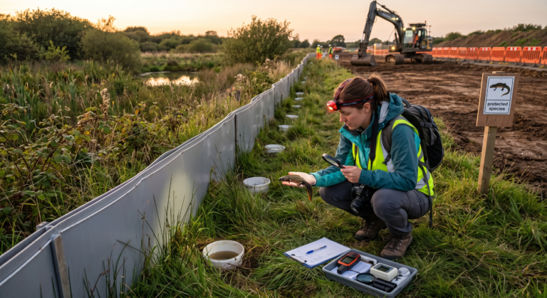
Beyond habitat mapping, the ecologist records target notes – observations of specific features that have ecological significance beyond the broad habitat classification. A single dead tree with woodpecker holes in an otherwise unremarkable hedgerow. A culverted watercourse that might support water voles. A disused outbuilding with gaps in the roof structure that could provide bat roost opportunities. A patch of marshy grassland in a corner of a field that didn’t show up on any desk study. These notes are what give the report its practical value for planning purposes.
Desk study work accompanies the field survey – checking datasets for recorded protected species in and around the site, reviewing aerial imagery and historical mapping, checking local planning authority records for any relevant designations or previous ecological assessments on the site. A Phase 1 report without a desk study is a less complete picture than one that combines both.
When You Need One
Not every planning application requires a Phase 1 habitat survey, but the circumstances in which one is needed are broader than most people assume. Local planning authorities are required under the National Planning Policy Framework to ensure that the planning system contributes to the Government’s commitment to halt the decline in biodiversity. In practice, that means ecological surveys are requested fairly routinely for any development that might affect ecological features.
A Phase 1 survey is typically required or strongly advisable in the following situations:
| Situation | Why a Survey Is Needed |
|---|---|
| Greenfield development | Undeveloped land may support a wide range of habitats and species; baseline assessment required |
| Brownfield development | Apparently barren sites can support significant ecology; open mosaic habitat is a Priority Habitat type |
| Demolition of buildings | Buildings may support bat roosts, nesting birds, or other protected species |
| Works to or removal of trees and hedgerows | Hedgerows may be Important under the Hedgerow Regulations; trees may support bats or birds |
| Development near watercourses | Riparian habitats may support water voles, otters, or other protected species |
| Agricultural land conversion | Grassland and field margin habitats assessed for botanical value and species potential |
| Development in or near designated sites | SSSIs, Local Wildlife Sites, or Ancient Woodland nearby; potential for indirect impact |
| Biodiversity Net Gain assessment | BNG calculation requires a habitat baseline; Phase 1 survey provides that baseline |
The honest answer to “do I need a Phase 1 survey?” is: if you’re unsure, probably yes. Pre-application engagement with the local planning authority will usually clarify their ecological survey requirements for a specific site. Getting that clarity early – before the application is prepared – avoids the frustration of a planning officer requesting survey information that delays determination.
Seasonal Constraints – This Is the Bit That Catches People Out
A Phase 1 habitat survey can be carried out at any time of year, in principle. In practice, surveys conducted in the main growing season – roughly April to October – produce the most complete picture, because vegetation is in leaf, habitats are clearly differentiated, and species activity is at its peak. A survey conducted in January is possible, but bare deciduous vegetation, dormant grassland, and low species activity can make habitat classification less precise and mean that ecological features present in summer are missed or underestimated.
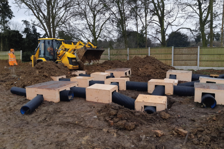
More importantly, the Phase 1 survey may trigger Phase 2 surveys for specific species, and those surveys have strict seasonal windows. Great crested newt surveys can only be conducted between mid-March and mid-June. Bat transect surveys need to be done in summer. Breeding bird surveys need to be done between April and July. Dormouse surveys require the summer and autumn period. If a Phase 1 survey is conducted in late autumn and triggers the need for, say, great crested newt surveys, the next opportunity to carry out those surveys may be the following spring – several months away, during which the planning programme stalls.
This is why timing the Phase 1 survey correctly is important. Ideally, it should be commissioned early enough that if Phase 2 surveys are triggered, those surveys can be carried out in the same field season. For most development projects, that means getting the Phase 1 done in spring or early summer rather than waiting until the planning application is nearly ready to submit.
What the Report Contains
A Phase 1 habitat survey report typically runs to twenty to forty pages for a medium-sized site, though the length varies with site complexity. It contains a site description, the methodology used, a desk study review, a description of each habitat present, a Phase 1 habitat map, target notes, a section on potential for protected species, and recommendations for further survey work where warranted.
The recommendations section is the one that planning applicants read most carefully – it’s where the ecologist sets out what additional surveys are needed before the application can be fully supported ecologically. Those recommendations drive the next stage of survey work and, ultimately, any mitigation or enhancement that forms part of the planning application.
Reports typically have a validity period of around two years for planning purposes, though this isn’t fixed in legislation and some local planning authorities apply different standards. A survey conducted two or more years before the planning application is submitted may need to be updated or revalidated, particularly if site conditions have changed in the interim.
How Long It Takes and What It Costs
For a straightforward site – a single field, a small parcel of brownfield land, a domestic property with garden – the field survey itself typically takes half a day to a full day. Report writing adds further time. From commissioning to receiving a completed report, two to four weeks is a reasonable expectation for most standard sites. Larger, more complex sites take longer both to survey and to report.
Cost varies with site size and complexity. For a small site – under a hectare – fees typically start from around £500 to £800 for survey and report. Medium sites of a few hectares might be £800 to £1,500. Larger or more complex sites are priced accordingly. These are rough figures; the specifics depend on the ecological context, the site access, and the level of desk study required.
Our Phase 1 habitat survey services cover the full process from desk study through field survey to completed report – and include clear advice on whether Phase 2 surveys are needed, what those surveys involve, and when they can be carried out. Because what most clients want at this stage isn’t just a report – it’s a clear picture of what comes next and how it fits into their programme.
Frequently Asked Questions
Can I commission a Phase 1 survey before I own the land?
Yes, subject to getting access permission from the current landowner. Pre-purchase ecological surveys are common and sensible – knowing what ecological constraints exist on a site before completing a purchase affects both the price negotiation and the development feasibility assessment. A landowner refusing access for pre-purchase ecological survey is itself a flag worth noting.
Does a Phase 1 survey identify all protected species on a site?
No. A Phase 1 survey identifies habitats and flags potential for protected species – it’s a screening tool, not a comprehensive species inventory. Confirmed presence or absence of protected species requires targeted Phase 2 surveys using species-specific methods. The Phase 1 report will recommend which species surveys are needed based on the habitats present and the desk study findings.
What happens if no ecological issues are found?
If the Phase 1 survey finds no significant ecological features and no requirement for further survey, the report says so – and that conclusion supports the planning application by demonstrating that ecological constraints have been assessed and are not a material issue. A clean Phase 1 report is a positive outcome, not a redundant exercise.
Who is qualified to carry out a Phase 1 habitat survey?
Phase 1 surveys should be carried out by a suitably qualified ecologist – typically someone with a relevant degree and CIEEM membership or working towards it, with demonstrable experience of Phase 1 survey methodology. Local planning authorities and statutory consultees expect surveys to be carried out by qualified practitioners; reports produced by unqualified individuals are unlikely to be accepted as adequate for planning purposes.
The Foundation of Ecological Assessment
A Phase 1 habitat survey is the starting point for understanding what a site holds ecologically. It’s not the most complex or the most expensive element of ecological work on a development project – that distinction usually belongs to whichever Phase 2 survey it triggers. But it’s the foundation on which everything else is built, and getting it done at the right time, by the right person, makes every subsequent step easier.
Commission it early. Read the recommendations carefully. And if it triggers Phase 2 surveys, get those into the programme before the planning application timetable is fixed rather than after. That sequencing, more than anything else, is what keeps ecological survey requirements from becoming programme problems.
Killingley Insights is the editorial voice of NT Killingley Ltd, drawing on decades of experience in landscaping, environmental enhancements, and civil engineering projects across the UK.